Rothes railway station
Appearance
Rothes | |
|---|---|
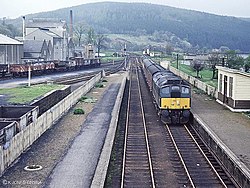
 The station in 1968 | |
| General information | |
| Location | Rothes, Moray Scotland |
| Coordinates | 57°31′43″N 3°12′23″W / 57.5285°N 3.2064°W |
| Grid reference | NJ278493 |
| Platforms | 1 (initially) 2 (later added) |
| Other information | |
| Status | Disused |
| History | |
| Original company | Morayshire Railway |
| Pre-grouping | Great North of Scotland Railway |
| Post-grouping | London and North Eastern Railway British Rail (Scottish Region) |
| Key dates | |
| 23 August 1858 | Opened |
| 6 May 1968 | Closed |
Rothes railway station served the town of Rothes, Moray, Scotland from 1858 to 1968 on the Morayshire Railway.
History
[edit]
The station opened on 23 August 1858 by the Morayshire Railway. To the west was a goods yard which started small, but was later enlarged when a platform to Elgin East was added. The station closed to both passengers and goods traffic on 6 May 1968.[1][2]
References
[edit]- ^ Quick, M E (2002). Railway passenger stations in England, Scotland and Wales - a chronology. Richmond: Railway and Canal Historical Society. p. 346. OCLC 931112387.
- ^ Butt, R. V. J. (October 1995). The Directory of Railway Stations: details every public and private passenger station, halt, platform and stopping place, past and present (1st ed.). Sparkford: Patrick Stephens Ltd. p. 200. ISBN 978-1-85260-508-7. OCLC 60251199. OL 11956311M.
External links
[edit]| Preceding station | Disused railways | Following station | ||
|---|---|---|---|---|
| Birchfield Halt Line and station closed |
Morayshire Railway | Dandaleith Line and station closed | ||
| Rothes Line and station closed |
Morayshire Railway | Sourden Line and station closed |
